Sunday, October 27, 2013
How to awkwardly clean a trout
I took a friend of mine fishing last weekend in the Eastern Sierra. It was her first time fishing ever. I told some coworkers about it and the V.P. of my department wanted video proof of me gutting a fish, so here it is.
Wednesday, July 4, 2012
Getting back on the trail: Tilden Regional Park
 |
| View of Mount Diablo from tree swing on Volmer Peak |
Well, well, well. It's been a long time for this blogger! I've been discouraged by some foot issues in the last couple of years, but finally decided “To hell with it. I'm gonna start doing some real hiking again.” Also, I have one of those milestone birthdays coming up and I wanted to do a trip-to-remember sort of trip, so I'll be hiking Mount Whitney in September and need to start training and get into some assemblance of backpacking shape.
Since it was a nice day, but not too hot, and because I'm still recovering from a twisted ankle, I decided a double-track fire trail up on a ridge with views may be a good option. I pulled out my Tilden map and opted to go with a trail and trailhead I had never tried before. Plus I would get to visit Volmer Peak for the first time which I've often viewed from a distance at Sibley Volcanic Regional Preserve.
I found the Seaview Trail to be quite pleasant for a fire trail (I generally hate fire trails due to the greater sun exposure) and there were many spots with wide views easterly and westerly including: Oakland, San Francisco Bay, San Francisco, Mount Tamalpais, the Pacific Ocean, Mount Diablo, the San Pablo and Briones Reservoirs, and beyond. Every once in a while the trail would be shaded by monterey pine and eucalyptus groves. There were spots of sticky monkey flower, lupin, sage, poppies, yerba santa, bright red berries of coast elderberry, blackberries, and of course poison oak.
The Lower and Upper Big Spring Trails were unspectacular, but it was nice to get on some single track trail for variety. They were partially shaded in spots by eucalyptus groves. I also made a side trip to the top of Volmer Peak which, like many Bay Area peaks, is covered in radio/cell towers. However, there were definitely good partial views east, west, and south, but not 360 views, and there was a homemade swing hung from a pine that has a very nice easterly view (see photo above).
Trailhead: Stream Trains area; Water, toilets, and poster trail map (sometimes there are free paper maps available).
Mileage: ~5.5
Elevation Gain/Loss: 1,300 feet
Hike Type: Lollipop loop
Trails Hiked:
Trail Type/Terrain: Double track/fire road, paved in beginning; single track. Lots of small cobbles in spots.
- Seaview Trail (a.k.a. Bay Area Ridge Trail/East Bay Skyline Trail);
- Lower Big Springs Trail;
- Upper Big Springs Trail;
- Seaview Trail with spur up to Volmer Peak (paved).
Trail Users: Hikers, mountain bikers, horses, dogs.
Official Park Website: Tilden Regional Park

Saturday, April 2, 2011
USGS Video: Unraveling the Mystery of Avian Navigation
The USGS (U.S. Geological Survey) in Menlo Park holds a monthly lecture series on scientific topics for the general public. Unfortunately I often can’t make it down to Menlo Park, but the good news is that they post a video archive of all the lectures online.

This past Thursday the lecture was: “Unraveling the Mystery of Avian Navigation: New research indicates that birds are listening to the landscape to find their way.” By Jon Hagstrum, Research Geophysicist. It’s basically this scientists research about “infrasound” and how pigeons may use it to navigate. There have been many theories over the years about how birds find their way “home” particularly pigeons, and none of them have really stood up to scientific testing. There is a little bit of physics involved in this lecture, but not too much, and these videos are really aimed at the general public viewing audience. I found it to be a really interesting topic, and if you are in to birds or navigation you should check it out.
Other USGS links:
Friday, March 18, 2011
Happy Super Moon Vernal Equinox!
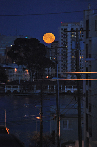
(Not a perigee moon but big nonetheless. Full Moon Set over Oakland, CA, March 21, 2008. Photo by Rebecca Bond.)
Tomorrow, March 19, 2011, we will not only have a full moon, but the moon’s orbit of the earth will be at Perigee (<—click for NASA explanation webpage)—meaning the closest distance of the moon to the earth in the moon’s orbit. Full moon perigee this close to the earth only happens approximately every 18 years. If you are lucky enough to have clear skies tomorrow evening, be sure to get out your camera and be ready to shoot as the moon shows up over the horizon. It should look super huge! Well actually 14% bigger and 30% brighter according to NASA. But, once it's up in the sky it may not look that much different than a regular full moon except brighter, and unfortunately, we are predicted to have rain all weekend long in most of California, so no go for me.
But wait, there’s more! Astronomical events that is... The Vernal, or Spring, Equinox is on Sunday, March 20, 2011, meaning the sun will be directly above the equator and daylight will be about 12 hours. A better explanation can be found at timeanddate.com.
Here’s a youtube video from NASAScience explaining the “Super Full Moon”:
Sunday, December 12, 2010
Unique ecology classes at the community college level are being threatened with cancelation
This fall I discovered natural history courses offered through the Biology department at Merritt College in Oakland. In my last blog post, Lassen Volcanic National Park Field Trip, I wrote about my experience. If you are into hiking, camping, fishing, adventure travel etc., these classes are great opportunities to learn about the natural world around you.
Ever wonder what kind of wildflower that is blooming along the trail? Or what kind of bird that is you always see wading on the shore? These are excellent classes to take to answer your questions, and because they are offered through the community college system, they are open to anybody and are often offered nights and weekends. Unfortunately, these classes are on the chopping block. Enrollment needs to increase or they will be eliminated.
Also at risk of landing on the chopping block, Merritt College has an Environmental Science and Technology department. It offers certificates in:
- Fundamentals of Environmental Management: Stewardship and Ranger/Naturalist
- Greening the Urban Environment
- Agroecology
I believe these programs are very unique at the community college level, and a great opportunity for students that can’t afford the exponentially exploding university fees to earn credit towards a degree in environmental studies.
This semester Merritt is offering the following courses:
- Natural History of Maritime Provinces and Newfoundland (BIOL 48OZ)
- Bird Songing: The Ecology of Bird Songs/ID By Ear (BIOL 80B)
- Introduction to Sustainable Systems (ENVMT 2)
- Introduction to Ranger/ Naturalist Outdoor Education (ENVMT 8)
- Introduction to Urban Argo Ecology (ENVMT 35)
- Special Projects in Ecological Planning, Implementation and Maintenance (ENVMT 50)
- Sustainable Projects (ENVMT 501)
- Environmental Photography & Photo Monitoring I (ENVMT 210A)
- Environmental Geology (through the geology department) (GEOL 12)
For more information visit the following links:
- District site for class schedule search, application & enrollment info: www.peralta.edu
- Merritt College homepage: www.merritt.edu
- The Environmental Management and Technology Program: www.ecomerritt.org
- The Environmental Management and Technology Program on Facebook: www.facebook.com/ecomerritt
- Birding/Bird Watching course instructor site: danielsmerrittclasses.blogspot.com
Subscribe to:
Posts (Atom)


