Sunday, December 12, 2010

Unique ecology classes at the community college level are being threatened with cancelation

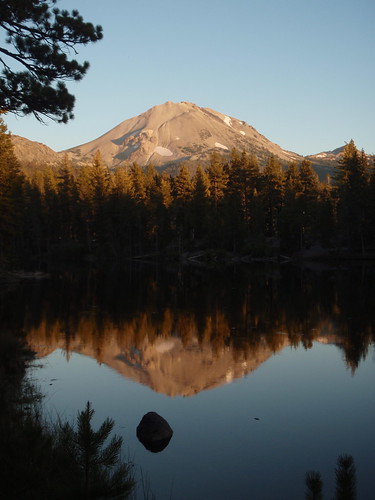
This fall I discovered natural history courses offered through the Biology department at Merritt College in Oakland. In my last blog post, Lassen Volcanic National Park Field Trip, I wrote about my experience. If you are into hiking, camping, fishing, adventure travel etc., these classes are great opportunities to learn about the natural world around you.

Ever wonder what kind of wildflower that is blooming along the trail? Or what kind of bird that is you always see wading on the shore? These are excellent classes to take to answer your questions, and because they are offered through the community college system, they are open to anybody and are often offered nights and weekends. Unfortunately, these classes are on the chopping block. Enrollment needs to increase or they will be eliminated.

Also at risk of landing on the chopping block, Merritt College has an Environmental Science and Technology department. It offers certificates in:
  • Fundamentals of Environmental Management: Stewardship and Ranger/Naturalist
  • Greening the Urban Environment
  • Agroecology
I believe these programs are very unique at the community college level, and a great opportunity for students that can’t afford the exponentially exploding university fees to earn credit towards a degree in environmental studies.

This semester Merritt is offering the following courses:
  • Natural History of Maritime Provinces and Newfoundland (BIOL 48OZ)
  • Bird Songing: The Ecology of Bird Songs/ID By Ear (BIOL 80B)
  • Introduction to Sustainable Systems (ENVMT 2)
  • Introduction to Ranger/ Naturalist Outdoor Education (ENVMT 8)
  • Introduction to Urban Argo Ecology (ENVMT 35)
  • Special Projects in Ecological Planning, Implementation and Maintenance (ENVMT 50)
  • Sustainable Projects (ENVMT 501)
  • Environmental Photography & Photo Monitoring I (ENVMT 210A)
  • Environmental Geology (through the geology department) (GEOL 12)
For more information visit the following links:

Saturday, October 2, 2010

Lassen Volcanic National Park Field Trip

P9250106

This fall I’m taking two classes: one is an Introduction to Geographic Information Systems at Diablo Valley College, and the other is a field studies class through Merritt College: Biol62H — Natural History of Lassen Volcanic National Park. This past weekend I went on the field trip portion of the natural history class to Lassen Volcanic National Park. I camped at Manzanita Lake Campground in the northwest corner of the park on Friday and Saturday nights in the “Tents Only” loop D.

Day One:
  1. We met at the Loomis Visitor’s Center/Museum at 8:30 am to check out the interpretive displays and watch a film about the park.
  2. Drove to the northeast section of the park and did the hike to Cinder Cone rim near Butte Lake.
  3. Later we did the Lily Pond Nature Trail with an additional walk around Reflection Lake.
Day Two:
  1. We met at the Manzanita Lake boat launch to do some bird watching but there was not too many birds out. We did see a Dipper (water ouzel), American Robin, a Stellar's Jay, Belted Kingfisher, and an immature Wood Duck.
  2. After, we drove to the Devastated Area to do the interpretive trail there, but it was closed for trail work.
  3. Met the trailhead for Lassen Peak (trail also under construction) for a short discussion about the flora/fauna/geology of Lassen Peak area.
  4. After we drove to the Bumpass Hell trailhead for a hike into Bumpass Hell, an active hydrothermal area.

A few volcanic fun facts I learned about Lassen on the trip:
  • Lassen Peak is one of the largest lava plug dome volcanoes in the world.
  • Currently, it is the last volcano to have erupted in California with major events happening from May 14, 1914 through May 22, 1915.
  • Lassen V. N. P. has examples of all four types of volcanoes: sheild—Prospect Peak, cinder cone—Cinder Cone, lava plug dome—Lassen Peak, and composite/stratovolcano—old Brokeoff/Tehama.
  • Cinder Cone National Monument and Lassen Peak National Monument were both established by Theodore Roosevelt on May 6, 1907.
  • After the eruption of Lassen Peak, Congress created Lassen Volcanic National Park in 1916.
A few common species of trees in the Lassen area that we identified:
~OR~
  • Here is my GPS track map with photos at Everytrail:

Tuesday, May 11, 2010

Backpacking: Point Reyes National Seashore—
Sky Camp

P5080689

I went on my first official backpack (not including snowcamping) of 2010 this past weekend in Point Reyes National Seashore to Sky Camp near Mt. Wittenberg. On Saturday, I hiked in by myself, but planned on meeting up later with some friends from a Yahoo! hiking group I’m a member of—Nor Cal Hikers. I really liked hiking in alone and then meeting a fun group of people in camp. I was able to have a leisurely no rush morning and peaceful hike at my own pace and then an evening of laughter and good company.

On Sunday it rained on and off in the morning, so I decided to try cooking in the partially open vestibule of my tent. Luckily the tent was a steal of a deal on clearance for a third of the original price, so I was not heartbroken when I discovered I melted a little hole in the vestibule fabric that drooped near the flame—nothing a little duct tape can’t fix!

I hiked in via Mt. Wittenberg Trail and out via Meadow Trail. Round trip mileage from Bear Valley Visitor Center to Sky Camp and back is less than eight miles (with a side trip to the disappointing summit of Mt. Wittenberg) but a good climb. An easier and shorter route is from the trailhead on Limantour Rd. via Sky Trail which is the route my friends took.

Related Link:View my pictures and GPS track & Map on EveryTrail:
Map your trip with EveryTrail

Sunday, January 17, 2010

Sweeney Ridge GGNRA Night Hike

P1130468
On Wednesday night I drove to San Bruno to meet my friend Marie for a night hike at Sweeney Ridge—part of the Golden Gate National Recreation Area (GGNRA). We started from the Sneath Lane trailhead and walked along the paved Sneath Lane Trail to the top at Sweeney Ridge trail. It was foggy higher up so we couldn’t see anything except mist, but lower down under the “fog line” I was able to get a shot of the city lights below us. The only wildlife we encountered was a banana slug that seemed a little out of place slithering along the pavement. We did see a dismembered fawn’s leg along the trail—probably the remnants of a coyote or mountain lion kill.

Trip Stats:
  • Trailhead: Sneath Lane (end of the road).
  • Mileage: ~3.75 round trip
  • Elevation +/-: 760 ft.
  • High Point: 1214 ft.
  • Low Point: 600 ft.
  • TH Facilities: None
View a few photos here on flickr.

View map with photos of my route on EveryTrail:

Sunday, January 3, 2010

First Hike of 2010

P1020434

My mountaineering friend Emilie invited me to go on a day hike with two of our friends at Huddart Park, a county park in San Mateo near Woodside, California. I haven’t done much Peninsula hiking and have never been to Huddart Park, so I thought it would be nice to start the new year with a hike in a new area.

The weather was nice and foggy with a little mist—perfect for hiking in redwood trees. With the moisture came lots of fungi, moss, lichen, and banana slugs. We even saw two rough-skinned newts cruising around with each other. We did have to dodge some horse apples, but the trails were remarkably root-free and not too muddy. Some trails where even paved, which was a bit odd, but minimized my normal stumbling on every rock and bump.

Overall it was a nice park, worth the small entrance fee, and a pleasant way to start the new year!

Trip Stats:
  • Location: Huddart County Park, Woodside, CA
  • Trailhead: Ranger Station Parking Lot
  • Mileage: 8.14 round trip, figure-8 loop
  • Elevation Gain/Loss: ~1,760 ft; low point 666 ft, high point 2,010 ft
  • Trails Traveled: Dean Trail, Chinquapin Trail, Archery Fire Road, Dean Trail, Crystal Springs Trail
  • Terrain: Well-maintained single and double track, some trails with asphalt. Good sturdy trail signage. Only a few obstacles—a couple downed trees, a few locked horse gates.
  • Flora & Fauna: Redwood forest and mixed evergreen with lots of madrone and tan oak. Lots of moisture, fungi, banana slugs, fog, spider webs, newts.
  • Facilities: Bathrooms with water at various picnic areas in park. $5 entrance fee. Maps available.
  • Flickr photo album

EveryTrail GPS Track with Photos: Huddart Park: First Hike of the New Year


Map your trip with EveryTrail